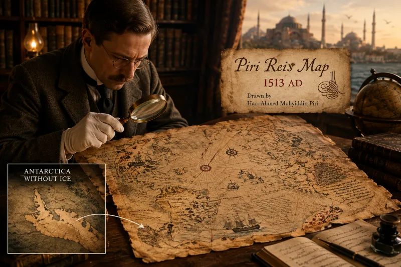
In October 1929, Gustav Adolf Deissmann, who was a German theologian, while visiting parts of the Topkapi Palace Library in Istanbul, a map caught his attention. This map was drawn up and signed by Captain Haji Ahmad Muhyiddin Piri, nicknamed Piri Reis, who was one of the most famous Ottoman navy, dating back to 1513 AD. And that's why this map became known as the Piri Reis map. According to Piri Reis, he used 20 source maps and charts to draw the map, including 8 Ptolemaic maps, 4 Portuguese maps, one Arabic map and one drawn by Christopher Columbus. Since the discovery of this map, there have been many disagreements, because the map indicated that Antarctica had been discovered 300 years before Antarctica was discovered by modern facilities. But there was something strange on the map that surprised the researchers. According to the map, in the distant past there was no ice in Antarctica. This map depicted the islands, valleys, rivers and bays of the Antarctic coast.
The world's oldest known maps date back to classical antiquity, dating from the sixth century BC to the 5th century BC, based on a flat earth pattern. Until the Greeks, for the first time in the Hellenistic period, were able to make a cylindrical map based on their knowledge of a spherical Earth as well as being able to use astronomy and geometry to calculate latitude and longitude. However, it was not used by Europeans until after the sixteenth century. Because it was not possible to draw the map precisely until 1760. Although the Greek maps and charts can be described as wonderful, based on the knowledge and possibilities of that period, there is no trace of Antarctica in these maps. The idea of Antarctica was initiated by an English captain named Captain Matthew Flinders and named Terra Australis, meaning South-land, as a hypothetical continent. It then appeared on maps between the 15th and 18th centuries, but was not discovered. The theory was that the land in the Northern Hemisphere should be balanced with land in the Southern Hemisphere.
Until 1773, the continent was officially discovered by James Cook and his crew. Hopgood put forward a theory that the source of the Piri Reis map was before 4000 BC, that is, before any known civilization. This theory suggests that a pre-historical civilization had advanced technology to move through the main seas and draw a fairly accurate map of the Earth. Hapgood also stated that topographic imaging of the continents' interiors required aerial abilities, implying the existence of an advanced civilization in the ancient world.
The map shows that Antarctica and South America were once interconnected in Uruguay and that Argentina was not yet there.
Gradually, the Piri Reis map went into oblivion, until the 3 Pyramids came out of the Antarctic ice, and it got people's attention. These 3 pyramids are very similar to the famous Egyptian pyramids. Two of these pyramids are 2 kilometers from the coastal waters and the third pyramid is near the beach. Historical evidence shows that it was about 6000 years ago that humans began building the pyramids. And that is why the possibility of humans living in this area 6000 years ago was strengthened. And it drew the experts' attention to the Piri Reis map and Hopgood's theory. The researchers looked at the map, using seismic sounds and sonar, surveyed Antarctica, and what they found surprised everyone. They found that beneath the Antarctic ice, there were coastlines, mountains, and plateaus, and matched everything that was on the Piri Reis map.
Then Ohlmeyer, in charge of British and Swedish expeditions to Antarctica, wrote a letter to Hapgood:
"We have no idea how the data on this map can be reconciled with the supposed state of geographical knowledge in 1513"
Hapgood writes in his book :
no matter what the origin of the snow pyramids can be, The discovery of these mysterious structures raises speculations about the possible habitation of humans in Antarctica in ancient times.
With the extraordinary theory of Hapgood, one question arises: What unknown civilization had mapping technology and facilities in the Antarctic region 6,000 years ago?
On this map, the west coast of Europe, North Africa and the coast of Brazil are with high precision mapped. Various islands of the Atlantic, including the Azores and the Canary Islands, are depicted. And around the edges of the map there are extensive notes in Turkish referring to the lost civilization of Atlantis.
Let's take a look at the Piri Reis Map. Look at the red area exactly on the line between the North and South Atlantic.
Buzz Aldrin, who walked on the moon with Neil Armstrong, tweeted a mysterious tweet and shortly deleted it. "We are all in danger; it is the devil itself," he wrote in the tweet. Why did he have such a tweet?